
A destination that we’ve discovered in the last few years is Ozark National Scenic Riverways. This area is run by the National Park Service and is located in south-central Missouri (about 2.5-3 hours from the St. Louis area). We’ve had a lot of fun exploring the various sites in this area. A list of the sites that we’ve visited is included below. There are so many great destinations within Ozark National Scenic Riverways, but our favorites are Rocky Falls/Klepzig Mill and Alley Spring and Mill.
- Alley Spring and Mill
- Big Spring
- Blue Spring
- Devil’s Well/Cave Spring
- Klepzig Mill
- Rocky Falls
- Welch Spring Hospital Ruins
- Round Spring

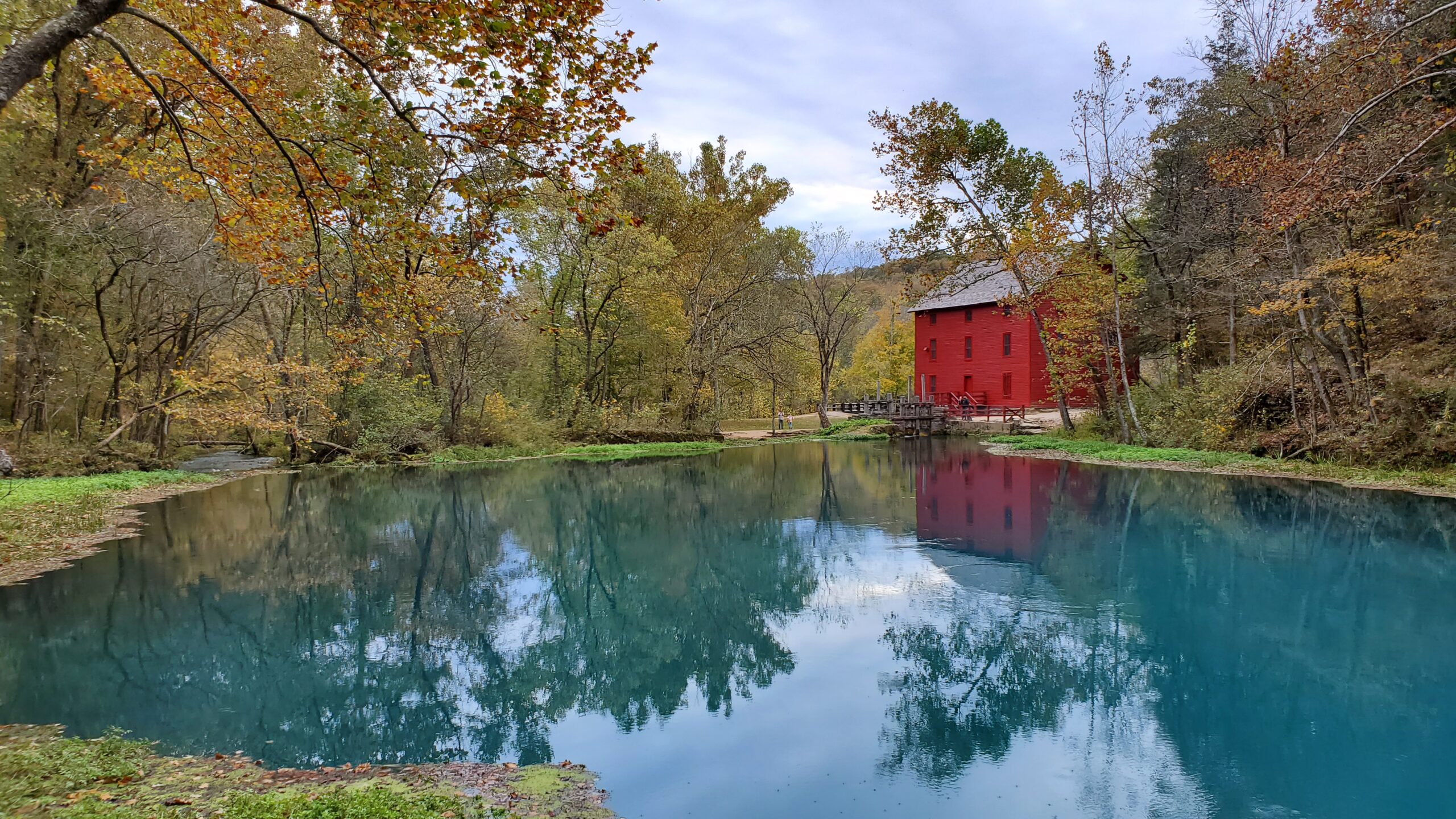
Alley Spring and Mill
This is one of our favorite stops in Ozark National Scenic Riverways. It is located about 6 miles west of Eminence, MO. The contrast between the bright blue water of the spring and the deep red of the mill is striking. This site is easy to access. The parking lot is off Highway 106. From the parking lot, it’s a short walk to the mill. There is also an old schoolhouse in the field near the mill. During certain hours, the mill is open and available for touring.


There is a short trail (approx. 0.3 miles) around the spring and mill. A longer trail (approx. 1.3 miles) climbs up to an overlook, continues over the hill, and then comes back down on the other side of the spring. It’s a steep climb up to the overlook, but it does provide a spectacular view of the area.

Across the highway from Alley Spring and Mill is the Alley Spring Campground, which is located on the Jacks Fork River. We’ve never camped here, but we have driven through it to check it out for a possible future camping trip. There are several loops inside the campground. One loop has sites with electric hookups. A link to the Recreation.gov site for this campground can be found here.
Big Spring
Big Spring is actually a VERY big spring. In fact, it is one of the top three largest springs in America. Big Spring was actually a Missouri State park for many years. It was eventually donated to the National Park Service and became part of Ozark National Scenic Riverways. It is located about five miles south of Van Buren, MO.

At Big Spring, like at Alley Spring, you can walk all the way around the spring. You can see in the pictures above that the water is flowing out of the spring so quickly, it almost looks like whitewater rapids on a river. It’s really an impressive site!
You can take the trail around the spring (The Slough Trail) and double back or keep going and continue on to make a loop by taking the Stone Ridge Trail. This trail will climb up on top of the bluff above the spring. The two trails combined are about 2.5 miles.

Big Spring also has a campground. We’ve never camped here, but we have driven through to check it out. The campground is located in the back of the park near the Current River. Most of the sites are basic (no hookups), but there are a few with electric hookups. A link to the Recreation.gov site for the Big Spring campground can be found here.

In the park there is a lodge and old cabins built by the Civilian Conservation Corps during the Great Depression. There is currently a renovation process taking place to restore these older buildings.

Blue Spring
While the blue water of the other springs has more of an aqua/turquoise tint to it, Blue Spring’s water is truly a dark blue. This is because of the dramatic depth of the spring. The impressive stat that I always remember from our first visit is that the Statue of Liberty could fit in this spring and would be completely underwater. It is over 310 feet deep. Blue Spring is located off the Current River, a few miles south of Highway 106 (about 14 miles east of Eminence, MO).


To get to Blue Spring by vehicle requires driving a couple miles down a narrow gravel road. This road ends in a parking lot with restrooms and a trail to the spring. It is a short walk (about 0.25 miles) from the parking lot. An alternative is to hike from Powder Mill campground, which is just south of Highway 106. Everything I have read claims that the trail is 0.5 miles to the spring (1 mile round trip), but when we’ve hiked this in the past, our Garmin watches indicated that it was closer to 3 miles round trip. It’s a nice hike along the Current River, but it did surprise us when it was quite a bit longer than we expected.

Devil’s Well/Cave Spring
Devil’s Well is a deep underground lake. There is a stairway to a lookout point where you can see the lake down below. To get to Devil’s Well requires driving a couple miles down a narrow gravel road. It is located off Highway KK west of Highway 19.


The Cave Spring trail starts at the Devil’s Well parking lot. It is approximately 4.6 miles long and climbs up and over hills and bluffs, drops down to the Current River, and then loops back to the starting point. Cave Spring is along this trail. Water from Devil’s Well makes its way to Cave Spring, which runs into the Current River.
Rocky Falls & Klepzig Mill
Rocky Falls
One of my favorite places in Ozark Scenic Riverways is Rocky Falls. It’s a great site for a picnic and is the starting point for one of my favorite hikes in the area. Rocky Falls is about a 14 mile drive east of Eminence, MO. Most of the roads required to get to Rocky Falls are paved with only a short drive on a gravel road to get to the parking lot. There are some vault toilets near the parking lot and several picnic tables spread around the area.


You can hike to the top of Rocky Falls to get a close-up of the creek at the top and a view of the pool at the base of the falls. If it’s recently rained, be careful on the way up. The large rocks near the top can be very slippery.
Klepzig Mill
A hike that we really enjoy starts downstream from the waterfall. It is a relatively flat 3-mile (one-way) hike to the nearby Klepzig Mill. You begin by crossing Rocky Creek (which can be tricky if the water is high). Then continue on for a short distance until you reach the Ozark Trail. At this point, you make a left turn (head north) on the Ozark Trail toward Klepzig Mill.

The Ozark Trail crosses Rocky Creek several times. There are also some stretches where it follows the creek. We’ve hiked this route twice. Both times we’ve been fortunate enough to see the wild horses that reside in this area. The first time we saw two horses in the woods. The second time we saw at least a dozen horses in one of the clearings.


The Ozark Trail passes right by Klepzig Mill. You can’t miss it. We like to pack snacks or a light lunch to eat at the mill before turning around to head back to Rocky Falls. If it’s warmer and the water is not too high, you can wade into the creek to cool off. You can also reach Klepzig Mill via a narrow gravel road. There is a small parking area near the mill.
Round Spring
We’ve hiked into Round Spring from Echo Bluff State Park, and we’ve done the cave tour there. At the time of our visit (July 2023) tours were at 10:00, 12:00, and 2:00. They were limited to 15 people and tickets must be purchased from within the park (no advanced reservations). It was a cool tour (great for a hot day) and only a short drive from Echo Bluff. Round Spring is part of Ozark National Scenic Riverways, so it is run by the National Park Service. If you’d like to read more details about the tour, here’s a link to the Round Spring Cave page on the NPS website: Round Spring and Round Spring Cave – Ozark National Scenic Riverways (U.S. National Park Service) (nps.gov).

Welch Spring Hospital Ruins
Back in the early 1900’s, a hospital was built over the opening of a cave. The idea was that the cool cave air would help to heal patience with “consumption”. It was not successful and the hospital is now a ruin. It is located about 8 miles west of Highway 19 off of Highway K. This is another location that requires a drive down a narrow gravel road. From the parking lot, it is about a mile hike to the spring and ruins.

Other Sites
The Ozark National Scenic Riverways NPS website has a detailed list of sites to visit in the area. We haven’t been to all of them, but we’ve visited quite a few. A link to this page can be found here.
If you can’t already tell, one of our favorite activities in Ozark National Scenic Riverways area is hiking. There are great hikes at many of the sites in the area. Here is a link to the NPS website’s hiking page for Ozark National Scenic Riverways.
Floating on the River
There are many options for floating on the rivers in the area. We canoed on the Current River. We used Carr’s Canoe Rental for our float trip. They picked us up from our campsite at Echo Bluff State Park and dropped us back off at the end of the day. We chose the full-day (19-mile) option and had a great time!


Camping/Lodging
When we visit Ozark National Scenic Riverways, we often camp in Echo Bluff State Park. Echo Bluff is a newer state park with a campground and a lodge with cabins on site. We like to camp here because it gives us the option to hike within the park or drive 30-45 minutes to visit several other Ozark National Scenic Riverways sites. Click here to read more about our experiences at Echo Bluff State Park.

As mentioned above, some of these sites have their own campgrounds for tent or RV campers. A detailed list of campgrounds within Ozark National Scenic Riverways can be found on the NPS website here.