
With all the well-known national parks in Utah, I think that Capitol Reef National Park often gets overlooked. This is a shame because it is such an amazing park! It has a little bit of everything: scenic drives, arches, canyons, and tasty pies!
Capitol Reef has some amazing features, but one thing it doesn’t have: crowds! During our mid-August visit, we never had an issue finding parking – even in the middle of the afternoon. We did a lot of hiking and saw few people while out on the trails.

Hiking
We went on some great short/medium-length hikes during our visit. We hiked to Cassidy Arch, Grand Wash, Sunset Point, and Hickman Bridge.


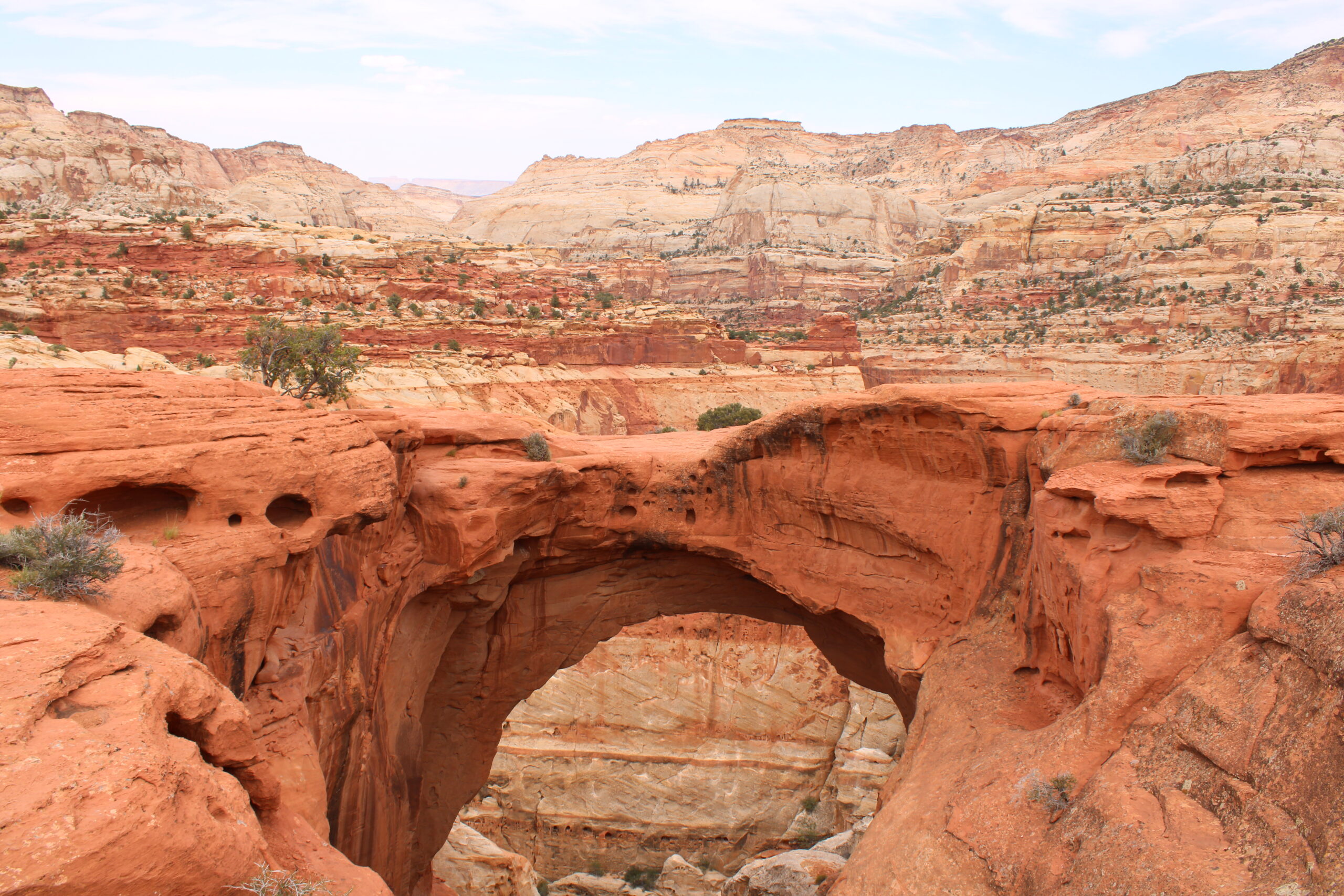
Cassidy Arch
- Quick Facts
- Length: 1.7 miles one-way
- Elevation Gain: 670 ft
- Trailhead/Parking: Grand Wash Road Trailhead Parking Lot
- Link to NPS site

I love hiking to a destination – whether it’s a mountain peak, lake, waterfall, or (in this case) an arch. The trail climbed quite a bit at the beginning of the hike. We quickly rose above the parking lot and continued to climb higher on the red rock.

After a while the climbing became more gradual. Roughly halfway there, we came around a bend and we could actually see the Cassidy Arch in the distance. It’s always reassuring to lay eyes on your destination.

As we got closer to the arch, the trail disappeared entirely due to the lack of dirt/sand and we were hiking across solid red rock. We followed cairns to stay on course. Then, all of a sudden, we rounded a corner, and the arch was right there!

Grand Wash
- Quick Facts
- Length: 2.2 miles one-way
- Elevation Gain: 200 ft
- Trailhead/Parking: Grand Wash Road Trailhead Parking Lot or Trailhead off Hwy 24 (East of Fruita)
- Link to NPS site
While we didn’t hike the whole length of Grand Wash, we did hike through the narrows portion. It was so cool walking through this narrow canyon! The hike was easy with little elevation gain. We added it to the end of our Cassidy Arch hike.


While hiking in this area, you’ll want to keep an eye on the weather. Flash flooding can be a real danger in this region.
Sunset Point
- Quick Facts
- Length: 0.4 miles one-way
- Elevation Gain: <50 ft
- Trailhead/Parking: Goosenecks/Sunset Point Parking Lot off Hwy 24 (West of Fruita)
- Link to NPS site

Sunset Point is a really cool place to go for sunset but know that it’s not necessarily a place to go to watch the sun go down. At the time we visited (mid-August) the sun was setting almost directly behind us. It was still worth the short hike to see the rocks lit up by the orange glow of the setting sun. The views reminded me a bit of Monument Valley.

Also note that the drive to the trailhead does have a stretch of gravel road. This road was a little hillier and windier than Grand Wash Road, which was a gravel road in great shape.
Hickman Bridge
- Quick Facts
- Length: 0.9 miles one-way
- Elevation Gain: 400 ft
- Trailhead/Parking: Hickman Bridge Parking Lot off Hwy 24 (East of Fruita)
- Link to NPS site
Hickman Bridge is a natural rock bridge. We got up early and hiked to Hickman Bridge in the morning. We were the first people in the parking lot and had the trail to ourselves until we turned around to come back. This was a fun hike with some elevation gain early on. There were lots of great views of the taller rock formations in the area.


Then we headed down into a sandy, yet fairly lush area between rock walls. There was another, smaller arch in this area. We continued on from here to a fork in the trail. It splits near the end and forms a small loop that passes under Hickman Bridge.


A short time after the split, we arrived at Hickman Bridge. A really cool feature of this hike is that the trail actually passes through the natural bridge. It was cool to see it from both the front and the back.


After passing under the bridge, the trail begins to loop back to the main route. On the way, there’s a great lookout point with an expansive view of the area. We stopped, took in the view, and then headed back down the trail to the parking lot.

Petroglyphs
While not necessarily a true “hike”, we stopped at the petroglyphs pull-off on the way back to camp after hiking Hickman Bridge trail. There is a board walk that follows along the rock cliff. You can see petroglyphs at various points along the rock wall. If you don’t feel like walking down the longer stretch of boardwalk along the rock cliff, you can walk the short stretch that runs directly toward the cliff face from the parking lot to see some great petroglyphs.

Scenic Driving
Honestly, driving almost anywhere in this park is a “scenic drive”. However, there is an “official” scenic drive road directly in the middle of the park. On our trip, we prioritized hiking over scenic driving and didn’t make it too far beyond Grand Wash Road on the scenic drive. On a return trip, I’d like to drive the whole stretch, stopping at overlooks for photos and quick hikes.

Orchards/Gifford Farm
A unique feature of this park is the orchards. There are a variety of fruits available at different times of the year in these orchards. The orchards were originally started in this area by pioneers in the 1880s. To read more about these orchards, check out the page on the Capitol Reef NPS site: Orchards – Capitol Reef National Park (U.S. National Park Service) (nps.gov).

The historic Gifford Farm is located along the scenic drive in the park. The Gifford house has been transformed into a shop with unique replicas of historic cooking utensils and locally baked pies. We each got a small (individual-sized) pie, and they were delicious! To read more about the Gifford House, check out this link to the NPS website: Gifford Homestead – Capitol Reef National Park (U.S. National Park Service) (nps.gov).
Camping/Lodging
We were fortunate enough to get a spot at Fruita Campground inside the park. There were no hookups. We relied on our solar and battery for power and didn’t have a problem! It was great to be close to the sites inside the park. To read more about our camping experience at Fruita Campground, check out the blog post: Fruita Campground – Miles of Yellow Lines.

Wish List
On a future visit to Capitol Reef, I’d like to drive the rest of the scenic drive road through the main part of the park. There are several additional hikes and overlooks that I’d like to check out. There are also other sections of the park. We stayed in the main section near Fruita, but I’d love to explore some of the lesser-traveled sections.